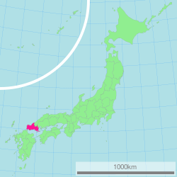
Yamaguchi Prefecture
| Yamaguchi Prefecture | |||||||||
|
|||||||||
 |
|||||||||
| Capital | Yamaguchi | ||||||||
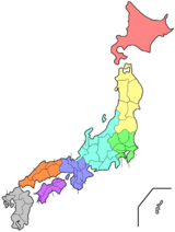
| Region | Chūgoku | ||||||||
| Island | Honshū | ||||||||
| Governor | Sekinari Nii | ||||||||
| Area (rank) | 6,110.94 km² (22nd) | ||||||||
| - % water | 2.6% | ||||||||
| Population (February 2006) | |||||||||
| - Population | 1,490,072 (25th) | ||||||||
| - Density | 248 /km² | ||||||||
| Districts | 5 | ||||||||
| Municipalities | 22 | ||||||||
| ISO 3166-2 | JP-35 | ||||||||
| Website | www.pref.yamaguchi.lg.jp/foreign/ english/index.html |
||||||||
| Prefectural symbols | |||||||||
| - Flower | Bitter summer mandarin blossom (Citrus natsudaidai) | ||||||||
| - Tree | Red pine tree (Pinus densiflora) | ||||||||
| - Bird | Hooded crane (Grus monacha) | ||||||||
| - Fish | Tetraodontidae (Takifugu rubripes) | ||||||||
 Symbol of Yamaguchi Prefecture |
|||||||||
| Template ■ Discussion ■ WikiProject Japan | |||||||||
Yamaguchi Prefecture (山口県 Yamaguchi-ken) is a prefecture of Japan located in the Chūgoku region on Honshū island. The capital is the city of Yamaguchi located in the center of the prefecture. The largest city, by contrast, is Shimonoseki.
Contents |
History
Yamaguchi Prefecture was made up of seven counties which were integrated into the two provinces of Suō and Nagato in the 7th century. During the rise of the samurai class during the Heian and Kamakura Periods (794–1333), the Ouchi family of Suō Province and the Koto family of Nagato Province gained influence as powerful warrior clans. In the Muromachi Period (1338—1573), Ouchi Hiroyo, the 24th ruler of the Ouchi family conquered both areas of Yamaguchi Prefecture. The Ouchi clan imitated the city planning of Kyoto. They gained great wealth through cultural imports from the continent and trade with Korea and Ming Dynasty China. As a result, Yamaguchi came to be known as the "Kyoto of the West," and Ouchi culture flourished. Sue Harutaka defeated the 31st ruler of the Ouchi clan. The Sue clan was then defeated by Mori Motonari, and the Mori family gained control of the Chugoku region. It was ruled by the Mōri clan domain during the Sengoku period. Mori was then defeated by Tokugawa Ieyasu in the battle of Sekigahara in 1600. He was forced to give up all his land except for the Suō and Nagato areas (current-day Yamaguchi Prefecture), where he built his castle in Hagi. After Commodore Matthew Perry's opening of Japan, clans from Nagato (also called Chōshū) played a key role in the fall of the Tokugawa shogunate and the establishment of the new imperial government. Mori sought to strengthen the economic base of the region and increase local production with his Three Whites campaign (salt, rice, and paper). Four years after the Edo Shogunate was overthrown and the Meiji government formed in 1868, the present Yamaguchi Prefecture was established. The Meiji government brought in many new systems and modern policies, and promoted the introduction of modern industry, though the prefecture was still centered around agriculture during this period. In the Taisho period, shipbuilding, chemical, machinery, and metal working plants were built in Yamaguchi's harbors in the Seto Inland Sea area. After the war during the Showa Period, the Petroleum collective was formed.[1]
Geography
Cities
|
|
Towns and districts
There are 4 districts and 6 towns in Yamaguchi Prefecture:
- Abu District:
- Abu
- Kuga District:
- Waki
- Kumage District:
- Hirao
- Kaminoseki
- Tabuse
- Ōshima District:
- Suō-Ōshima
Mergers
Future mergers
Tourism
The most popular place for tourism is Shimonoseki. One of the major attractions is the famous Kintai Bridge in the town of Iwakuni. This five arched wooden structure is considered a symbol of Western Honshū. The area on the banks of the Nishiki river close to the bridge is considered among the best places in Japan for Hanami, when groups of family and friends gather in early April to view cherry blossoms.
Transportation
Two ferry services provide regular sea transport from the Shimonoseki Port International Terminal: Kanpu Ferry provides round-trip service to Busan, South Korea; the Orient Ferry provides round-trip service to Qingdao and Shanghai, respectively.
Yamaguchi Ube Airport is a domestic airport with service to Tokyo et al.
Prefectural symbols
- Tree: Red pine tree (Pinus densiflora)
- Flower: Bitter summer mandarin blossom (Citrus natsudaidai)
- Bird: Hooded crane (Grus monacha)
- Fish: Tetraodontidae (Takifugu rubripes)
- Beast: Sika Deer (Cervus nippon nippon)
Media
Newspaper
- Yamaguchi Shimbun
TV
- YAB TV(ANN)
- KRY TV(NNN)
- TYS TV(JNN)
- NHK TV
Famous people from Yamaguchi
- Kido Takayoshi, one of the two main architects of the Meiji Restoration
- Former Prime Minister Shinzo Abe represented first Yamaguchi's 1st then 4th district in the House of Representatives; his father represented Yamaguchi as well.
- Atsushi Tamura of the comic duo London Boots Ichi-go Ni-go is from Shimonoseki in Yamaguchi.
- Teruzane Utada music producer, manager and father of Utada Hikaru is from somewhere in Yamaguchi Prefecture, as mentioned on the latter's blog.
- Sayumi Michishige, a Japanese idol who is one of the 6th generation members of Japanese idol group Morning Musume was also born in Yamaguchi.
- Raizo Tanaka, a Japanese rear admiral during World War II. Tanaka was the commander of the Midway invasion force and later made famous for his efforts to keep Japanese forces on Guadalcanal in supply with the "Tokyo Express."
- Prime Minister Naoto Kan was born in Ube in 1946.[2]
- Karyu, guitarist of the band D'espairsRay is from Yamaguchi. The band had a "homecoming" live there in 2007 and 2009.
- Harukichi Yamaguchi, founder of the Yamaguchi-gumi,born near Kobe but his entire family hailed from Yamaguchi.
- Shintaro Abe, former Minister of Foreign Affairs and General Secretary of the LDP.
References
- ↑ http://www.pref.yamaguchi.lg.jp/foreign/english/history.html The History of Yamaguchi Prefecture
- ↑ Kantei bio notes
External links
|
|||||||||||||||||||
|
|||||||||||||||||||||||||||||||||